
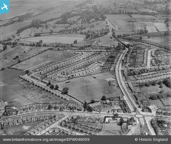
EPW048059 ENGLAND (1935). Housing development and sports ground off Coleshill Road, Hodgehill, 1935
© Hawlfraint cyfranwyr OpenStreetMap a thrwyddedwyd gan yr OpenStreetMap Foundation. 2025. Trwyddedir y gartograffeg fel CC BY-SA.
Manylion
| Pennawd | [EPW048059] Housing development and sports ground off Coleshill Road, Hodgehill, 1935 |
| Cyfeirnod | EPW048059 |
| Dyddiad | June-1935 |
| Dolen | |
| Enw lle | HODGEHILL |
| Plwyf | |
| Ardal | |
| Gwlad | ENGLAND |
| Dwyreiniad / Gogleddiad | 412744, 288815 |
| Hydred / Lledred | -1.8122612150291, 52.496725087349 |
| Cyfeirnod Grid Cenedlaethol | SP127888 |
Pinnau
 Rod |
Saturday 17th of August 2019 09:36:25 PM | |
Andy |
Wednesday 2nd of September 2015 05:42:17 PM | |
Ron41 |
Thursday 18th of December 2014 05:17:26 PM | |
Ron41 |
Thursday 18th of December 2014 05:16:19 PM | |
Ron41 |
Wednesday 17th of December 2014 08:00:34 PM | |
Ron41 |
Wednesday 17th of December 2014 07:56:03 PM | |
Ron41 |
Wednesday 17th of December 2014 07:55:08 PM |
Cyfraniadau Grŵp
I believe that though technically correct for the modern location , the title should really be Coleshill Road , Ward End .The large building above and right of the roundabout is the Beaufort Cinema , the building on its opposite corner is the Fox and Goose pub . The view looks east toward Coleshill , about 4 miles away . I lived on Stechford Road , which is the road entering the photo at top right--Hodge Hill Common is at the junction with Coleshill Road ;Stechford Road runs off Stechford Lane which is the road running right from the roundabouut , and the area was officially Ward End . For completeness , the three roads running off Coleshill Road to the right are Beaufort Avenue , Southbourne Avenue and Westbourne Avenue which all joined Stechford Road . |
mikanmart |
Wednesday 22nd of January 2014 12:12:01 PM |
Dear mikanmart Thank you very much for your comment. When cataloguing an image we base the placename on the centrepoint of the photo using the modern OS 50k placename gazetteer. It doesn't always make perfect sense! If the A4040 is the western boundary of Hodgehill then I'm happy for that to be the placename reflected in the caption for this particular image. Best wishes Laura (Britain from Above Cataloguer) |
 Laura Maddison |
Wednesday 22nd of January 2014 12:12:01 PM |