
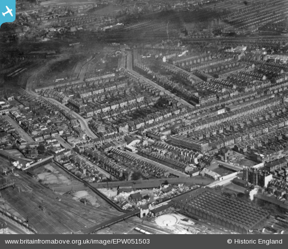
EPW051503 ENGLAND (1936). Turn Pike Lane, Harringay, 1936. This image has been produced from a print.
© Hawlfraint cyfranwyr OpenStreetMap a thrwyddedwyd gan yr OpenStreetMap Foundation. 2025. Trwyddedir y gartograffeg fel CC BY-SA.
Delweddau cyfagos (3)
EPW051503

EPW031503

EPW007401

Manylion
| Pennawd | [EPW051503] Turn Pike Lane, Harringay, 1936. This image has been produced from a print. |
| Cyfeirnod | EPW051503 |
| Dyddiad | August-1936 |
| Dolen | |
| Enw lle | HARRINGAY |
| Plwyf | |
| Ardal | |
| Gwlad | ENGLAND |
| Dwyreiniad / Gogleddiad | 531078, 189517 |
| Hydred / Lledred | -0.10767705598885, 51.588765391051 |
| Cyfeirnod Grid Cenedlaethol | TQ311895 |
Pinnau
 billyfern |
Friday 7th of November 2014 12:11:28 PM | |
billyfern |
Friday 7th of November 2014 12:10:19 PM | |
billyfern |
Friday 7th of November 2014 12:09:25 PM | |
billyfern |
Friday 7th of November 2014 12:08:14 PM | |
billyfern |
Friday 7th of November 2014 12:07:01 PM | |
billyfern |
Friday 7th of November 2014 12:05:41 PM | |
 Class31 |
Tuesday 28th of October 2014 09:11:57 PM | |
Class31 |
Tuesday 28th of October 2014 09:00:42 PM | |
Class31 |
Tuesday 28th of October 2014 08:59:48 PM | |
Class31 |
Tuesday 28th of October 2014 08:58:22 PM | |
Class31 |
Tuesday 28th of October 2014 08:57:48 PM | |
Class31 |
Tuesday 28th of October 2014 08:55:42 PM | |
Class31 |
Tuesday 28th of October 2014 08:54:51 PM |

Cyfraniadau Grŵp
I have to admit that this one was a gift for me as I have previously identified unlocated photos in this area. I have made one visit to the area and I know a little about the New River which was built to supply water to London. I have a photo which has been taken in the area and I'm a railway enthusiast. |
Class31 |
Tuesday 28th of October 2014 09:05:08 PM |