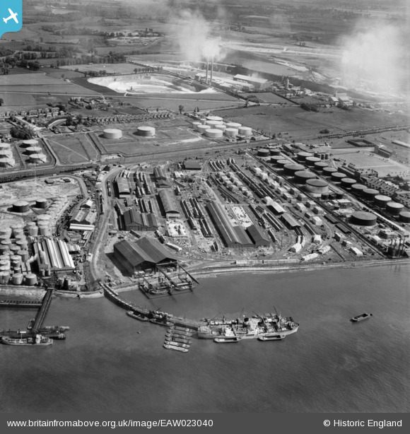
EAW023040 ENGLAND (1949). The Purfleet Deep Wharf & Storage Co Ltd site and environs, Purfleet, 1949
© Copyright OpenStreetMap contributors and licensed by the OpenStreetMap Foundation. 2025. Cartography is licensed as CC BY-SA.
Nearby Images (11)
Details
| Title | [EAW023040] The Purfleet Deep Wharf & Storage Co Ltd site and environs, Purfleet, 1949 |
| Reference | EAW023040 |
| Date | 10-May-1949 |
| Link | |
| Place name | PURFLEET |
| Parish | |
| District | |
| Country | ENGLAND |
| Easting / Northing | 556462, 177400 |
| Longitude / Latitude | 0.25311717068711, 51.473411099994 |
| National Grid Reference | TQ565774 |


![[EAW023040] The Purfleet Deep Wharf & Storage Co Ltd site and environs, Purfleet, 1949](http://britainfromabove.org.uk/sites/all/libraries/aerofilms-images/public/100x100/EAW/023/EAW023040.jpg)
![[EAW023039] The Purfleet Deep Wharf & Storage Co Ltd site and adjacent Esso Oil Depot, Purfleet, 1949. This image was marked by Aerofilms Ltd for photo editing.](http://britainfromabove.org.uk/sites/all/libraries/aerofilms-images/public/100x100/EAW/023/EAW023039.jpg)
![[EAW023045] The Purfleet Deep Wharf & Storage Co Ltd site and adjacent Esso Oil Depot, Purfleet, 1949](http://britainfromabove.org.uk/sites/all/libraries/aerofilms-images/public/100x100/EAW/023/EAW023045.jpg)
![[EAW023041] The Purfleet Deep Wharf & Storage Co Ltd site and environs, Purfleet, 1949. This image was marked by Aerofilms Ltd for photo editing.](http://britainfromabove.org.uk/sites/all/libraries/aerofilms-images/public/100x100/EAW/023/EAW023041.jpg)
![[EPW026350] The River Thames, Purfleet Wharf and Van den Berghs and Jurgens Ltd Margarine Works, Purfleet, 1929](http://britainfromabove.org.uk/sites/all/libraries/aerofilms-images/public/100x100/EPW/026/EPW026350.jpg)
![[EAW023046] The Purfleet Deep Wharf & Storage Co Ltd site and adjacent Esso Oil Depot, Purfleet, 1949. This image was marked by Aerofilms Ltd for photo editing.](http://britainfromabove.org.uk/sites/all/libraries/aerofilms-images/public/100x100/EAW/023/EAW023046.jpg)
![[EAW023038] The Purfleet Deep Wharf & Storage Co Ltd site and environs, Purfleet, 1949. This image was marked by Aerofilms Ltd for photo editing.](http://britainfromabove.org.uk/sites/all/libraries/aerofilms-images/public/100x100/EAW/023/EAW023038.jpg)
![[EAW023042] The Purfleet Deep Wharf & Storage Co Ltd site and environs, Purfleet, 1949](http://britainfromabove.org.uk/sites/all/libraries/aerofilms-images/public/100x100/EAW/023/EAW023042.jpg)
![[EAW023044] The Purfleet Deep Wharf & Storage Co Ltd site and environs, Purfleet, 1949. This image was marked by Aerofilms Ltd for photo editing.](http://britainfromabove.org.uk/sites/all/libraries/aerofilms-images/public/100x100/EAW/023/EAW023044.jpg)
![[EAW023043] The Purfleet Deep Wharf & Storage Co Ltd site and environs, Purfleet, 1949](http://britainfromabove.org.uk/sites/all/libraries/aerofilms-images/public/100x100/EAW/023/EAW023043.jpg)
![[EPW006266] Anglo Americam Oil Company, Purfleet, 1921](http://britainfromabove.org.uk/sites/all/libraries/aerofilms-images/public/100x100/EPW/006/EPW006266.jpg)
