
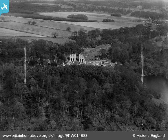
EPW014883 ENGLAND (1926). The ruins of Roche Abbey, Roche Abbey, 1926
© Copyright OpenStreetMap contributors and licensed by the OpenStreetMap Foundation. 2025. Cartography is licensed as CC BY-SA.
Nearby Images (7)
EPW014883

EAW003573

EPW014882

EPW014885

EPW014884

EAW003574

EAW003575

Details
| Title | [EPW014883] The ruins of Roche Abbey, Roche Abbey, 1926 |
| Reference | EPW014883 |
| Date | 29-May-1926 |
| Link | |
| Place name | ROCHE ABBEY |
| Parish | MALTBY |
| District | |
| Country | ENGLAND |
| Easting / Northing | 454369, 389805 |
| Longitude / Latitude | -1.1821543230933, 53.402003050113 |
| National Grid Reference | SK544898 |
Pins
 Maurice |
Friday 25th of January 2013 07:05:34 AM |
User Comment Contributions
View looking east. Beautifully set in a valley landscaped by ‘Capability’ Brown in the 18th Century. Roche Abbey has one of the most complete ground plans of any English Cistercian monastery, laid out as excavated foundations. |
 Class31 |
Wednesday 23rd of January 2013 10:18:46 PM |