
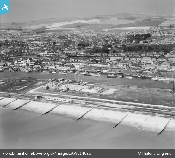
EAW014025 ENGLAND (1948). Shoreham Harbour and Brighton B Power Station under construction, Southwick, from the south, 1948
© Hawlfraint cyfranwyr OpenStreetMap a thrwyddedwyd gan yr OpenStreetMap Foundation. 2025. Trwyddedir y gartograffeg fel CC BY-SA.
Delweddau cyfagos (7)
EAW014025

EAW014029

EAW014028

EAW014026

EPW043906

EAW014021

EAW014027

Manylion
| Pennawd | [EAW014025] Shoreham Harbour and Brighton B Power Station under construction, Southwick, from the south, 1948 |
| Cyfeirnod | EAW014025 |
| Dyddiad | 23-March-1948 |
| Dolen | |
| Enw lle | SOUTHWICK |
| Plwyf | |
| Ardal | |
| Gwlad | ENGLAND |
| Dwyreiniad / Gogleddiad | 524749, 104807 |
| Hydred / Lledred | -0.22846351236077, 50.828779858897 |
| Cyfeirnod Grid Cenedlaethol | TQ247048 |
Pinnau
 KiwiMike |
Thursday 31st of March 2022 08:12:38 PM | |
 Matt Aldred edob.mattaldred.com |
Thursday 11th of March 2021 02:15:15 PM | |
redmist |
Friday 5th of February 2021 08:54:13 PM | |
redmist |
Friday 5th of February 2021 08:44:39 PM | |
redmist |
Friday 5th of February 2021 08:43:38 PM |