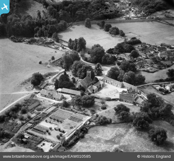
EAW010585 ENGLAND (1947). St Mary's Church, the Manor House and the village, Buriton, 1947
© Copyright OpenStreetMap contributors and licensed by the OpenStreetMap Foundation. 2025. Cartography is licensed as CC BY-SA.
Nearby Images (8)
Details
| Title | [EAW010585] St Mary's Church, the Manor House and the village, Buriton, 1947 |
| Reference | EAW010585 |
| Date | 3-September-1947 |
| Link | |
| Place name | BURITON |
| Parish | BURITON |
| District | |
| Country | ENGLAND |
| Easting / Northing | 474005, 120011 |
| Longitude / Latitude | -0.94581194808422, 50.974207519033 |
| National Grid Reference | SU740200 |
Pins
 totoro |
Friday 7th of August 2015 07:31:32 PM | |
 totoro |
Friday 7th of August 2015 07:30:30 PM | |
 totoro |
Friday 7th of August 2015 07:28:25 PM | |
 totoro |
Friday 7th of August 2015 07:27:41 PM | |
 totoro |
Friday 7th of August 2015 07:26:58 PM | |
 totoro |
Friday 7th of August 2015 06:52:20 PM | |
 totoro |
Friday 7th of August 2015 06:47:20 PM | |
 totoro |
Friday 7th of August 2015 06:46:31 PM |


![[EAW010585] St Mary's Church, the Manor House and the village, Buriton, 1947](http://britainfromabove.org.uk/sites/all/libraries/aerofilms-images/public/100x100/EAW/010/EAW010585.jpg)
![[EAW010588] St Mary's Church and the Manor House, Buriton, 1947](http://britainfromabove.org.uk/sites/all/libraries/aerofilms-images/public/100x100/EAW/010/EAW010588.jpg)
![[EAW010587] St Mary's Church, the Manor House and village, Buriton, 1947](http://britainfromabove.org.uk/sites/all/libraries/aerofilms-images/public/100x100/EAW/010/EAW010587.jpg)
![[EAW010586] St Mary's Church and the Manor House, Buriton, 1947](http://britainfromabove.org.uk/sites/all/libraries/aerofilms-images/public/100x100/EAW/010/EAW010586.jpg)
![[EAW010589] St Mary's Church and the Manor House, Buriton, 1947](http://britainfromabove.org.uk/sites/all/libraries/aerofilms-images/public/100x100/EAW/010/EAW010589.jpg)
![[EAW010590] St Mary's Church, the Manor House and the village, Buriton, 1947. This image was marked by Aerofilms Ltd for photo editing.](http://britainfromabove.org.uk/sites/all/libraries/aerofilms-images/public/100x100/EAW/010/EAW010590.jpg)
![[EAW010584] St Mary's Church, the Manor House and the village, Buriton, 1947](http://britainfromabove.org.uk/sites/all/libraries/aerofilms-images/public/100x100/EAW/010/EAW010584.jpg)
![[EAW010583] The village, Buriton Lime Works and environs, Buriton, 1947](http://britainfromabove.org.uk/sites/all/libraries/aerofilms-images/public/100x100/EAW/010/EAW010583.jpg)
